This guide covers the set up of the Planet Map 3D script, as well as detailing the various commands and features of the script.
QUICK SET UP
- Load this script on a programmable block.
- Put the tag “[MAP]” in the name of the block where you want the map to be displayed. If the block has multiple screens you can change which screen displays the map by going into the programmable block’s Custom Data field and changing the “MAP_Index” field.
- It’s recommended to map at least the basic movement and mode commands to desired hotkey bars.
- (optional)Paste “Vanilla” planet and waypoint data into the custom data field of the programmable block. (See below).
- (optional)Add the tag “[Map Data]” to the name field of a block that you want to have the Data Display screen. This display page will give details about planets, waypoints, and the map screen itself. (See section ‘Data Display Pages’ below).
COMMANDS
There are two options for running commands for this script:
1: RUN DIRECTLY FROM PROGRAM BLOCK
To do this, simply enter the command into the Argument field of the programmable block. This is a good option for commands like:
- LOG_WAYPOINT
- PLOT_JUMP
- COLOR_PLANET
2: MAP TO HOTKEYS
To do this, go to the G-menu for your desired interface (i.e. cockpit, command seat, button panel, etc) drag the programmable block to the target hot key, and select the action “Run”. This should prompt a dialog box, asking for an argument. Type your command here.
Some commands take multiple arguments such as NEW_PLANET. This argument would be followed by the name of the planet, which this guide will denote as <planet name>. You don’t need to include angle brackets, but make sure that there’s a space between the first argument and the second. It’s alright if the second argument has a space in it.
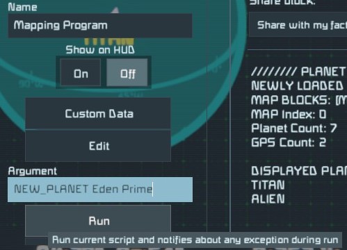
Example:
To create a planet named “Eden Prime” just run the argument:
NEW_PLANET Eden Prime
Rotational Controls
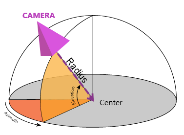
STEP ROTATION
Increment the rotation by a single step (default 5°):
- ROTATE_LEFT
- ROTATE_RIGHT
- ROTATE_UP
- ROTATE_DOWN
FLUID ROTATION
Increase or decrease the angular velocity of the azimuth, creating a continuous spin. Running the command multiple times will increase the velocity further, and running the opposite command will slow or stop the rotation (similar to increase/decrease velocity action for rotors).
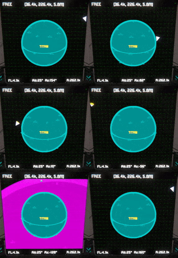
- SPIN_LEFT
- SPIN_RIGHT
Translational Controls
STEP TRANSLATION
Move the camera at fixed step length, based on the zoom level:
- MOVE_LEFT
- MOVE_RIGHT
- MOVE_UP
- MOVE_DOWN
- MOVE_FORWARD
- MOVE_BACKWARD
FLUID TRANSLATION
Increase the velocity of the camera so that it moves continuously in straight line. As with fluid rotation, these commands can be called multiple times to further increase the velocity, or the opposite command can be called to slow or stop the movement.
- TRACK_LEFT
- TRACK_RIGHT
- TRACK_UP
- TRACK_DOWN
- TRACK_FORWARD
- TRACK_BACKWARD
Zoom & Other Movements
Adjust the focal length of the map, effectively zooming in and out:
- ZOOM_IN
- ZOOM_OUT
ROTATIONAL RADIUS
Adjust the distance of the camera from the map’s rotational center:
- INCREASE_RADIUS
- DECREASE_RADIUS
STOP
Stop both rotational and translational fluid movement:
- STOP
CENTER SHIP
Set the map center to your ship’s current position:
- CENTER_SHIP
DEFAULTVIEW
Set all map parameters to their default value, including centering the map at (0,0,0):
- DEFAULT_VIEW
View Settings
Toggle all display of all waypoints:
- GPS_ON
- GPS_OFF
- TOGGLE_GPS
Toggle display of individual waypoints. Be sure to include a [space] between the command and the waypoint name.
- WAYPOINT_ON <waypoint name>
- WAYPOINT_OFF <waypoint name>
- TOGGLE_WAYPOINT <waypoint name>
NAMES
Toggle names on all waypoints and planets:
- SHOW_NAMES
- HIDE_NAMES
- TOGGLE_NAMES
INFO BARS
Toggle map parameter bars at top and bottom of map
- SHOW_INFO
- HIDE_INFO
- TOGGLE_INFO
BRIGHTNESS
Change Screen Brightness:
- BRIGHTEN
- DARKEN
Map Modes
Map remains static.
- FREE_MODE
WORLD
Similar to FREE mode, but the view is zoomed out and top down to give a broader perspective.
- WORLD_MODE
SHIP
The map centers on the ship, and follows it as it moves.
- SHIP_MODE
PLANET
Top down view of the ship as it travels across the surface of a planet.
- PLANET_MODE
CYCLE MODES
Cycle through map modes:
- NEXT_MODE
- PREVIOUS_MODE
CYCLE PLANETS
Cycle map focus through all charted planets (sorted nearest to farthest). Doing so will return the map to FREE mode.
- NEXT_PLANET
- PREVIOUS_PLANET
CYCLE WAYPOINTS
Cycle map focus through all charted waypoints. Doing so will return the map to FREE mode.
- NEXT_WAYPOINT
- PREVIOUS_WAYPOINT
Charting Waypoints
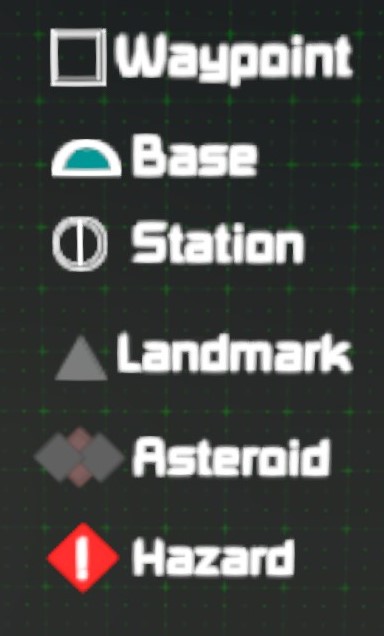
- LOG_WAYPOINT <waypoint name>
- LOG_BASE <waypoint name>
- LOG_STATION <waypoint name>
- LOG_LANDMARK <waypoint name>
- LOG_ASTEROID <waypoint name>
- LOG_HAZARD <waypoint name>
- DELETE_WAYPOINT <waypoint name>
PASTE FROM CLIPBOARD
Log waypoint of specified type by copying GPS data from terminal and pasting it into the argument:
- PASTE_WAYPOINT <waypoint name>
- PASTE_BASE <GPS string>
- PASTE_STATION <GPS string>
- PASTE_LANDMARK <GPS string>
- PASTE_ASTEROID <GPS string>
- PASTE_HAZARD <GPS string>
PLOT ORBITAL JUMP POINT
You can also plot a Waypoint just outside of a planet’s gravity well. This command will plot the jump point on a direct line between your ship and the planet center, and will automatically generate the waypoint name:
- PLOT_JUMP <planet name>
Charting Planets
SURFACE POINT 1
To begin charting a new planet, log its first surface point from your current position. The same naming rules as waypoints apply to planets.
- NEW_PLANET <planet name>
SURFACE POINTS 2, 3 & 4
Chart subsequent surface points for specified planet. After the 4th surface point, the planet should automatically be generated and added to the map.
- LOG_NEXT <planet name>
THAT’S NO MOON…
Unleash the awesome firepower of your fully armed and operational mapping script!!!
- DELETE_PLANET <planet name>
CHANGE PLANET COLOR
Recolor specified planet. Be sure to include [space] between command and color, as well as color and planet name.
- COLOR_PLANET <color> <planet name>
Valid color arguments (not case sensitive):
- RED
- BLUE
- GREEN
- YELLOW
- MAGENTA
- PURPLE
- CYAN
- LIGHTBLUE
- ORANGE
- TAN
- RUST
- GRAY
- GREY
- WHITE
Data Display Panel
In order to add the Data Display Panel, you will need to add the tag “[Map Data]” to the block where you want to add the display panel. You can also specify a different tag in the programmable block’s custom data, by changing the attribute “Data_Tag”. You can also change the screen it selects by changing “Data_Index”.
PAGE NAVIGATION
- NEXT_PAGE
- PREVIOUS_PAGE
- SCROLL_UP
- SCROLL_DOWN
- SCROLL_HOME
EXPORT WAYPOINT
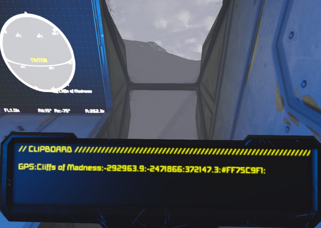 Generate a GPS string formatted to be pasted into terminal. This string will appear on the “Clipboard” (page 4) of the display screen. It can be copied from that screen’s text field.
- EXPORT_WAYPOINT <waypoint name>
PLANET LIST
The following planets and moons are from the default star system. You can add them to the map by pasting the following data into the Custom Data field of the programmable block. They may not be accurate to some scenarios such as Never Surrender. NOTE: Be sure to include the trailing semi-colons.
Planet_List=
|EARTHLIKE;(0,0,0);60000;GREEN;;;;
|MOON;(16388,136375,-113547);9394;GRAY;;;;
|MARS;(1032762,134086,1632659);64606;RUST;;;;
|EUROPA;(916410,16373.72,1616441);9600;LIGHTBLUE;;;;
|ALIEN;(131110.8,131220.6,5731113);60894.06;MAGENTA;;;;
|TITAN;(36385.04,226384,5796385);9238.224;CYAN;;;;
|TRITON;(-284463.6,-2434464,365536.2);38128.81;WHITE;;;;
These geographic oddities may be worth a visit, just for the view, or for something more? Waypoints can be pasted into Custom Data the same way that planets can.
Waypoint_List=
|Cliffs of Madness;(-292963.9,-2471866,372147.3);LANDMARK;ACTIVE
|Olympus Mons;(1035143,117597.2,1695051);LANDMARK;ACTIVE
Related Posts:
- Space Engineers: How to Setup my Executor Class Super Star Dreadnought
- Space Engineers: Ore Finder Plus [OFP] Guide 2022
- Space Engineers: How to Change Gravity
- Space Engineers: How to Create an Auto Airlock
- Space Engineers: XB-1 Manual 2021 (Drone & Armament)

