This is a nearly comprehensive guide to the flight instruments for Flight of Nova. A map of the numbers, gizmos, meters, and dowhatsits you can find in your ship.
While based off of the shuttle craft, the instruments in this guide are also found in other ships. If a ship has special instruments, it will be featured separately.
This guide does not teach you how to fly, you can learn from doing Training missions and playing the game.
Note: This guide is currently missing a docking instruments section.
Basics of Flight Instruments
Most instruments are used both in atmospheric flight and in orbit. The most important are:
- Altitude
The ground hurts, especially when you meet it going too fast. Keep a careful eye on your altitude to avoid meeting it too early. Additionally, your altitude is important for catching orbital stations, don’t miss. - Velocity
If your altitude is 0m, and your velocity is 0m/s, you are either already dead or safely landed. Your velocity determines your risk of death, keep it well managed. - Throttle
Mismanagement will change your velocity quite rapidly, and it could get out of control. Get used to the power of your main rocket engines and handle the throttle wisely. - Hydrogen Fuel
Without fuel, your main rocket engines can’t help you. If you run out of fuel, you’re either going to be flying for a really long time, or a really short time. Don’t waste it!
While those were the most important instruments for flight, the others are just as useful, especially when pulling off tricky maneuvers. Take your time and relax, you don’t need to learn them all at once.
When learning to fly, practice in the atmosphere first, you will have a lot less to worry about than in orbital spaceflght.
External View
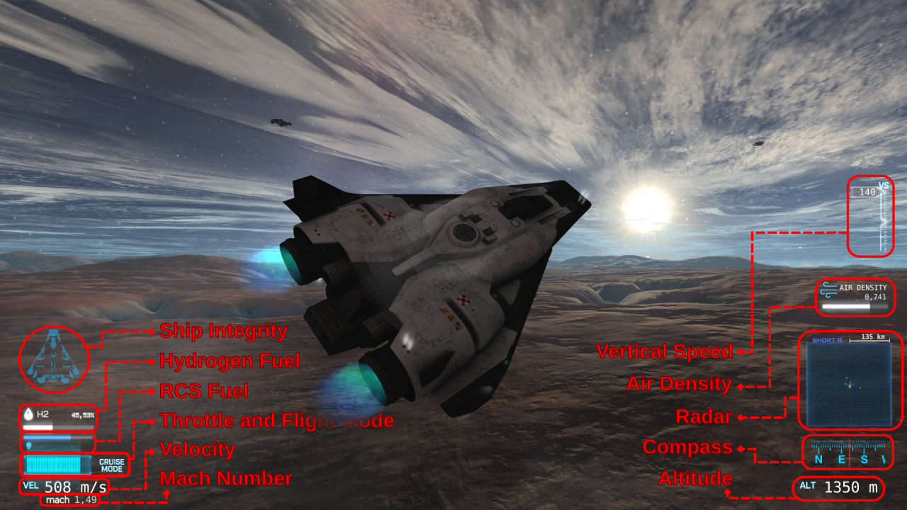
Displays the integrity of different sections of the ship as a graphic. By default all pieces are blue when in working order, but turn red when missing or damaged.
Fuel reserves for the main rocket engines, displayed as both a percentage and meter between full and empty. Hydrogen is used for both VTOL and Cruise mode. The main engines cannot provide thrust when Hydrogen is empty.
Fuel reserves for the Reaction Control System, displayed as a meter between full and empty. RCS thrusters move and turn the ship when in space. They stop functioning if fuel is empty.
(Currently infinite, but will become limited in a later game update)
The current throttle setting of the main rocket engines, displayed as a meter between full throttle and no throttle. A higher throttle setting causes the engines to produce more thrust, resulting in a faster speed at the cost of increased fuel consumption.
T-Lock (not pictured)
The throttle can be switched into T-Lock, or Throttle-Lock mode. When enabled, a text indicator “T-LOCK” is visible on top of the throttle meter. This mode will keep the throttle at its current setting when throttle input is released. You can increase the throttle setting with the Throttle + button, and decrease the throttle setting with the Throttle – button while T-Lock is engaged.
A indicator of the ship’s current flight mode. There are two possible flight modes:
- VTOL Mode
The main rocket engines point downwards and move the ship upwards. Uses more fuel. The initial mode when landed at a ground station. - Cruise Mode
The main rocket engines point backwards and move the ship forwards. More efficient than VTOL mode and used for quicker flight speeds.
The ship’s current speed, displayed in meters per second.
How close the ship’s Velocity is to the speed of sound. 1.0 is the speed of sound, 2.0 is two times the speed of sound, 5.0 is five times the speed of sound, and so on.
- (See Also: Mach Number[en.wikipedia.org])
Vertical Speed
Rate of change in altitude, displayed as meters per second inside a needle, which moves up and down on a vertical ruler ranging from +30.0 to -30.0 meters per second. Speeds outside of this range cause the needle to stop at the top or bottom of the ruler.
The thickness of the atmosphere at the current altitude. Higher air density increases atmospheric drag, which slows the ship down. Going too fast at high air density dramatically increases the hull temperature to dangerous levels. Lower air density allows you to reach and maintain speed at lower throttle settings, decreasing fuel consumption.
- (See Also: Density of air[en.wikipedia.org])
Displays nearby land bases and other ships. Land bases are orange dots, and other ships are green. The radar has two range modes:
- Short Range – Displays objects within 135km of the ship.
- Long Range – Displays objects within 900km of the ship.
A compass featuring N, E, S, and W marks for North, East, South, and West, along with a red line displaying the direction the ship is pointing. This is not necessarily where it is flying, if you are flying Eastbound and point the ship Southbound, the red line will point to the S on the compass, even though the ship is flying to the East.
The ship’s current height above sea level, displayed in meters. Valleys can go below sea level, so negative altitude is possible.
Cockpit View
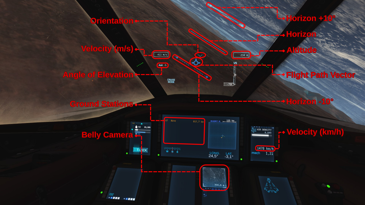
A symbol pointing at the direction the ship is facing. The level lines show the horizontal center, and the bottom tip of the V shows the vertical center. If a line was drawn from the tip of the V straight up, and the gap between the two level lines closed, you would see a cross hair at the exact direction the ship is pointing to.
Like in external view, displays the ship’s current speed in meters per second.
The difference between the ship’s orientation and the horizon, displayed in degrees. Has a range from 90° to -90°, with 0° being level with the horizon, 90° pointing directly up, and -90° pointing directly down.
A list of all ground stations visible on the short range radar. Displays their identifying number, purpose, and distance from the ship.
A live view from the ship’s belly camera, mounted on its belly and pointing straight down from the ship. Features a cross hair at the center of the view, and the distance from the ship to the cross hair displayed in meters.
Tracks a level orientation compared to gravity. Pointing the ship at this line brings the angle of elevation to 0°.
Features two dashed companion lines +10° up and -10° down. Pointing the ship at these lines brings the angle of elevation to 10° or -10°.
Like in external view, displays the ship’s current height above sea level in meters.
A symbol marking the direction of flight. The ship moves towards this mark.
This is different from the orientation symbol and points to the direction the ship is moving rather than where it’s facing. If this mark is above you the ship is moving upwards, if it’s behind you the ship is moving backwards, if it’s to your left the ship is drifting left, and so on.
Like other velocity indicators, shows the ship’s current speed, however this displays the speed in kilometers per hour rather than meters per second.
High Altitude Instruments
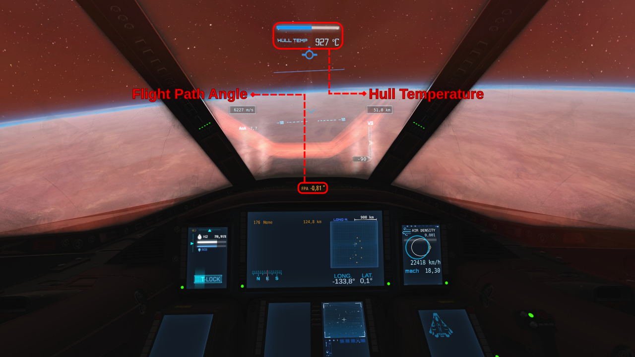
Similar to the angle of elevation, however instead of your orientation, displays the angle between your flight path vector and the horizon, shown in degrees. Like the angle of elevation, this is a range between 90° and -90°. A flight path angle of 0° means the ship is flying level with the horizon, 90° means the ship is flying straight up towards space, and -90° means the ship is flying straight down towards the ground.
The temperature of the ship’s hull, measured in degrees Celsius. Also includes a thermometer. This instrument is only visible past a minimum heat level, well below any dangerous temperatures, but still quite hot.
HEAT warning (not pictured)
When approaching the maximum safe temperature of your hull, a HEAT indicator will flash above the hull temperature instrument along with an alarm. You should stabilize your heat as soon as possible or the ship will begin taking permanent damage if it gets much hotter.
Orbital Computer
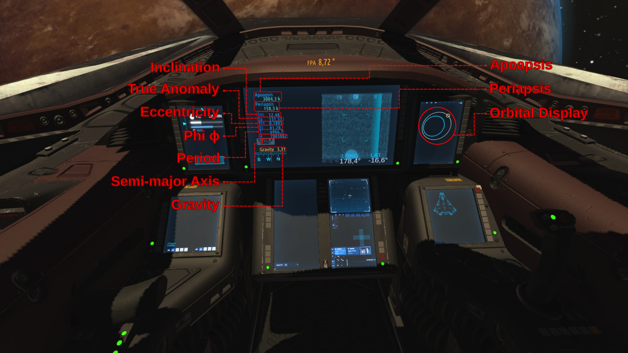
While in orbit—or just high enough to easily get into orbit—the orbital computer becomes availabe. It gives you very valuable information about your orbit which can be used to make orbital maneuvers, like changing your speed, altitude, and circularity of orbit, among other things.
- (See Also: Basics of Space Flight: Orbital Mechanics by Robert A. Braeunig[www.braeunig.us])
Altitude of the orbit’s highest point in meters.
Altitude of the orbit’s lowest point in meters.
How far off center the orbit is as an angle in degrees between 90° and -90°. This affects your latitude. 0° has the least effect on your latitude, and 90° or -90° has the most. 0° degrees is required to maintain an equatorial orbit.
The angle representing your position in the orbit. From 0° to 360°. When at the Periapsis the true anomaly is at 0°, and when at the Apoapsis it is at 180°. A number between 0° and 180° means you are headed towards the Apoapsis, and a number between 180° and 360° means you are headed towards the Periapsis.
Represents how close the orbit is to a circle. 0 is a perfectly circular orbit, 1 means your orbit will no longer repeat forever, and you will escape the planet, and numbers higher than 1 mean you are escaping the planet even faster.
This is like the Flight Path Angle, however instead of being relative to the horizon like the Flight Path Angle, Phi is relative to pointing directly away from the planet. This means that flying level with the horizon will make Phi 90° while your Flight Path Angle will be 0°. Conversely, flying directly away from the planet will make Phi read 0° and the Flight Path Angle read -90°.
How long it takes to complete one orbit in seconds.
Radius of the orbit’s longer dimension in meters.
- (See Also: Semi-major Axis[en.wikipedia.org])
How much the planet pulls the ship downwards in meters per second squared.
A graphical representation of your current orbit. The white oval represents the orbital path, the yellow dot represents the ship, and the blue circle represents the planet. If the white oval is touching the blue circle, or crosses inside of it, your orbit will take you back into the atmosphere and you will collide with the planet. Your orbit may take you inside the atmosphere even if it does not touch the blue circle.
(not marked in picture)
Indicates that your orbit will not take you beneath the atmosphere, and provided you don’t collide with any satellites or debris, you will orbit forever.
(not pictured)
Indicates that your orbit will escape the planet’s gravity and will not repeat. Appears when, your eccentricity is at or above 1.
(not marked in picture)
Displays a full-range surround radar which picks up nearby and distant objects. These light up blue on the scope.
The box in the middle shows the forward facing portion of the scope, it is likely you will be able to see objects out of the cockpit if they are within this box and close enough. Degree marks are visible at the top of the scope, 270°, 0°, and 90°. 180° is not marked at the top but is located the very left and right edge of the scope.
270° is to the left of the ship, 90° is to the right of the ship, 0° is directly in front, and 180° is directly behind. Keep in mind that when objects are behind the ship, you have to pitch the ship up and down the opposite direction to move them up and down on the scope.
Target Status and Interception
When you get close enough, a notification will sound, and interception instruments will activate and become visible to you. This includes a local flight path vector, and relative velocity indicator.
This section also covers the anti-flight path vector.
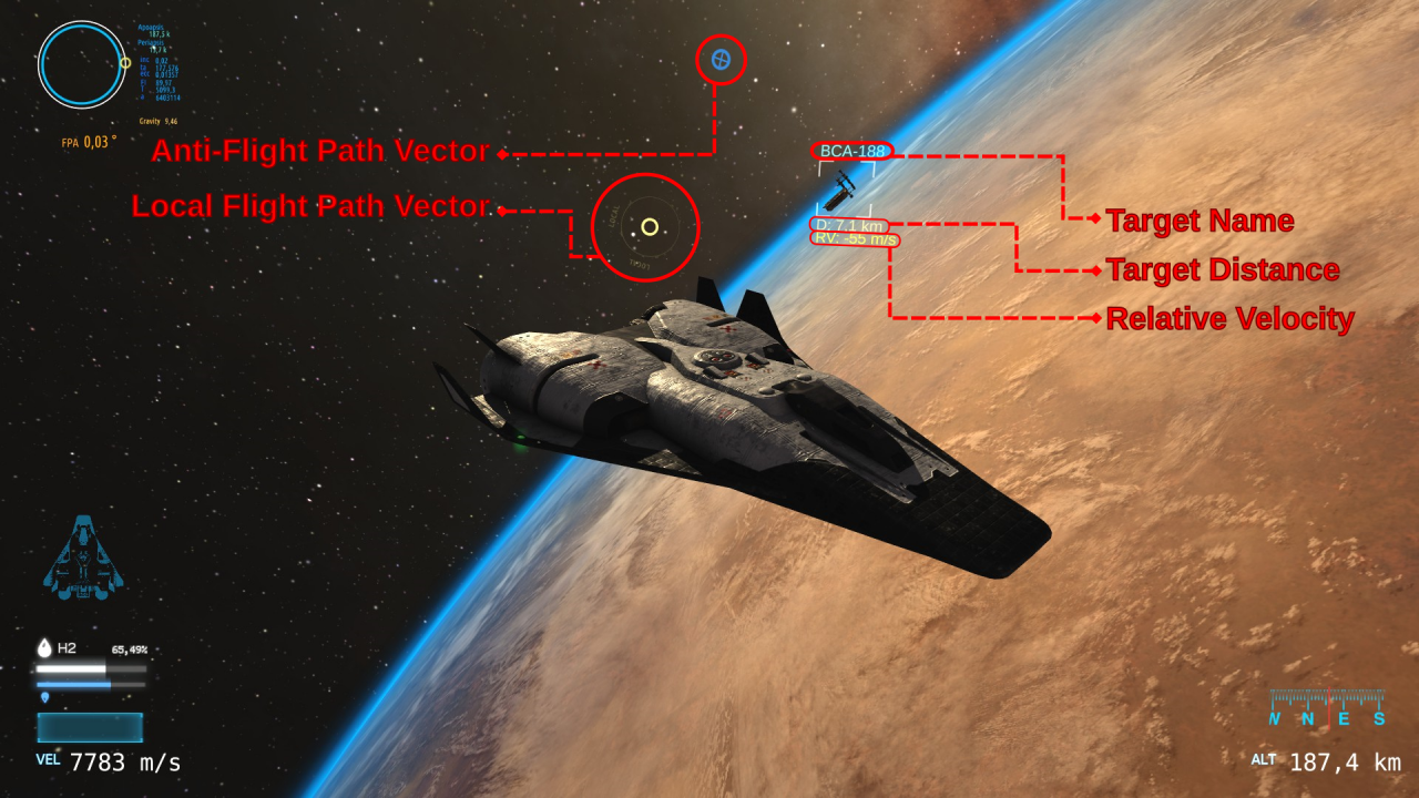
A symbol marking the direction opposite of the Flight Path Vector. The ship moves away from this mark.
This can be useful to help locate the flight path vector if you get disoriented, you can simply turn away from this mark in the opposite direction to find the flight path vector.
Visible when close enough to a target, this symbol marks the flight path vector relative to that target.
If this symbol is on top of the target, you are moving directly towards it, if it is up from the target, you are moving up, if down, down, and so on.
(not pictured)
This is similar to the Anti-Flight Path Vector, but is relative to the Local Flight Path Vector rather than the Flight Path Vector
If this symbol is on top of the target, you are moving directly away from it.
The identifier of the target. For orbital stations, the identifier consists of a short form of the target’s full name, followed by their stable orbit altitude.
Distance from the ship to the target in meters.
Displays the rate Target Distance changes, displayed in meters per second. This means you are moving towards or away from the target at this speed. Negative when moving towards the target, and positive when moving away.
This indicator has a yellow color when negative, and a red color when positive, to help quickly understand if you are moving towards or away from your target.
Thanks to JJRcop for his great guide, all credit to his effort. you can also read the original guide from Steam Community. enjoy the game.

